


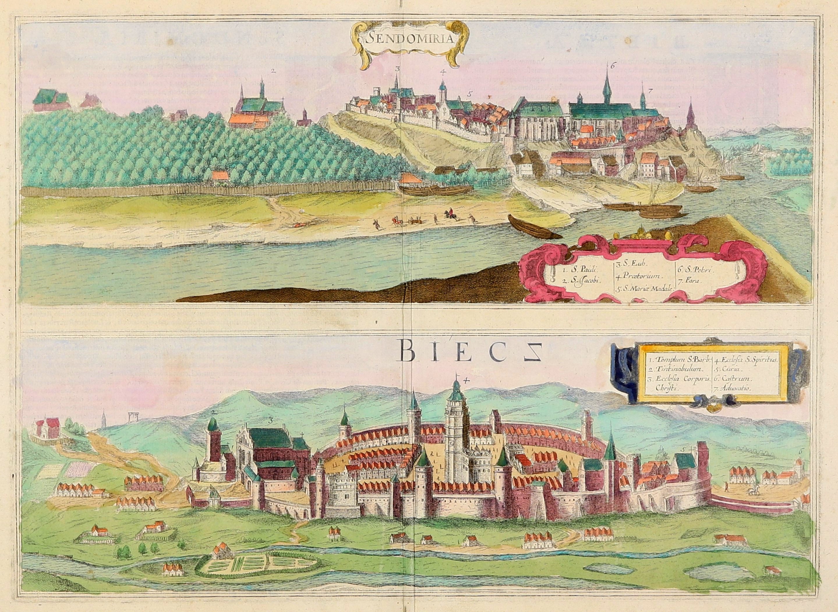
SANDIERZ, BIECZ. Panoramas of cities on a common sheet (reflected from one plate); taken from: Civitates Orbis Terrarum, ed. by G. Braun and F. Hogenberg, Cologne 1617; on verso, texts in Latin: SENDOMIRIA / BIETZA; copper color, bdb. condition, two minimal spots in margins, light creases, mild soiling, minimal loss in margin; plate dimensions 452x327 mm; tit. of view of Sandomierz in cartouche, under upper frame: SENDOMIRIA; tit. of view of Biecz under upper frame, without cartouche: BIECZ (letter Z in mirror image);[Imago Poloniae K103/4, Dantiscum G65/4].
Civitates orbis terrarum - a six-volume atlas of the world's cities, published in Cologne from 1572-1618 by Georg Braun (1542-1622) and Frans Hogenberg (1535-1590). Braun's intention was to complement the atlas Theatrum Orbis Terrarum by Abraham Ortelius, published in 1570. Civitates [...] contains 546 engravings depicting views of cities, mainly of Europe (especially German), but also of Asia, Africa and Latin America. From Polish cities, panoramas of Gdansk, Szczecin, Swiebodzin, Biecz, Cracow, Lublin, Lowicz, Poznan, Warsaw and Zamosc appeared here. Drawings were made by more than 100 cartographers, painters and printmakers, while the main engraver was Hogenberg (who had previously collaborated with Abraham Ortelius and made most of the engravings for the Theatrum). Latin, German and French editions were published. In addition to Braun and Hogenberg, contributors to the work include Joris Hoefnagel and his son Jakob, Jacob van Deventer (also known as Jacob Roelofszof), William Smith, Heinrich Rantzau (Rantzovius), Simon Novellanus and Cornelius Caymox. Woodcuts by Stumpf from the Schweizer Chronik (1548) and views and maps by Sebastian Münster, among others, were also used. The maps were supplemented with descriptions (mainly by Braun). Additional illustrations, such as city coats of arms or genre scenes with figures in regional costumes, were included alongside them. Beginning in 1653, successive editions of Civitates were printed by Jan Janssonius (Johannes Jansson), and later - after the original plates were repurchased - by Frederick de Wit.
Frans Hogenberg (c. 1535-1590) - painter, printmaker, engraver, cartographer and publisher; came from a family of engravers from Antwerp. He left his homeland due to political unrest and probably died in Cologne. He was active in France, Germany and Denmark, among other countries. He compiled the first road atlas of Europe Itinerarium Orbis Christiani, containing 84 maps. For 15 years he collaborated with Abraham Ortelius (1527-1598), making illustrations for the atlas Theatrum Orbis Terrarum, as well as with Georg Braun, with whom he co-authored the 6-volume atlas Civitates Orbis Terrarum (he was the author of most of the engravings).
Georg Braun (1541-1622) - German theologian, geographer, cartographer, engraver, printer and publisher. From his birth until his death he was associated with Cologne, where he held the office of parish priest.Author of the text for the atlas of plans and views of cities of the world Civitates Orbis Terrarum (6 volumes, 1572-1617), co-authored with Frans Hogenberg. Braun oversaw the work on this atlas - he was the owner of the tables and descriptions necessary for the design of the map, and he also associated cartographers and engravers, thanks to whom it was possible to continue the work.









